Clements Hall
Bishophill book cover crop for website

Clements Hall Local History Group

Exploring the Scarcroft, Clementhorpe, South Bank and Bishophill areas of York

Clements Hall Local History Group

Exploring the Scarcroft, Clementhorpe, South Bank and Bishophill areas of York

View navigation

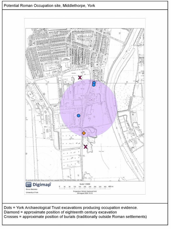
Was there a Roman settlement at Middlethorpe?

There’s a follow up by Simon Batchelor to our recent blogpost on the Terry’s site, with some intriguing research

Hopefully many of you will have read the report written by John Stevens and Mave Morris about their investigations into the history of the Terry’s factory site. They mentioned my research about a small Roman settlement possibly existing in this area.

Terry's site lies on high, relatively well drained land (part of the glacial moraine) two km to the south of the city of York. To the west lies the Knavesmire, which was 2,000 years ago a seasonal, shallow lake, and to the east lies the River Ouse, which at the time was bordered by tidal marsh and meadow. Thus we can picture the potential occupation area as a narrow spine of land extending along a north/south axis, a landscape which mirrors that on the western side of the Knavesmire where we find the 2nd century Roman settlement of Dringhouses.

Dringhouses possesses one very obvious characteristic of Roman presence, namely a road. The road to Tadcaster was designated road 10 by the Royal Commission for Historic Monuments and was the only road that they identified on the SW side of the river Ouse, heading south. Although historians thought that a road might exist which roughly aligned to Bishopthorpe Road, it was believed that it was likely to be a minor one.

So do we have a Roman road? And if so where is it and where does it go? 

Potential Roman Occupation site, Middlethorpe, York

In 1975 an examination of known Roman milestones and their relationship to the Antonine Itinerary found that a milestone near to the fort at Castleford stated that the distance to York was 22 Roman miles. It was concluded that this referred to an as yet unknown road between the two sites, as the distance to York via Tadcaster was greater. It was later suggested that this route, via Bolton Percy, would approach York along the line of the present Bishopthorpe Road, and this would better meet the distances recorded on the milestone.

In 1981, during a watching brief on the deep sewer work under Bishopthorpe Road, a compact cobbled surface some two metres below the current street level was observed. This discovery suggested that a road, provisionally numbered 12 in the RCHM(E) scheme, may exist and may head towards either Castleford or Doncaster, passing through Middlethorpe. Based on this idea, we can look at a possible alignment for the road.

If you examine a modern plan of our area you can see a straight boundary is visible, running from Cherry Hill Lane to Reginald Grove. This same boundary is visible on Lund’s Survey of Micklegate Stray, so is at least 350 years old. It is almost certain that the later development of the area was influenced by this boundary. It can also be suggested that such an obvious and almost straight boundary has been influenced by an earlier feature. Furthermore this boundary follows the contours of the landscape rather than climbing the steep escarpments of the glacial moraine as the modern road does. This would suggest that this boundary may represent the ‘ghost’ of our Roman road.

Such ‘ghost’ roads are not unusual for York. The modern Tadcaster Road runs slightly east of its Roman counterpart, the A19 between Bootham Bar and Water End sits almost directly on top of one of the Roman roads leading to Catterick and the road to Malton can be traced through the Groves via a number of narrow public lanes.

A possible destination may have been a military site in the Acaster area (-caster placename elements regularly coincide with former Roman military establishments), close to the confluence of the Ouse and Wharfe. This was an important control point for trading and supply vessels needing access to the two important Roman settlements of York and Tadcaster. 

Excavations carried out at 292 Bishopthorpe Road (St. Chad’s Wharf) in 1998, revealed some evidence of Roman activity in the form of a few sherds of Roman pottery and tile, along with some cobbles. In 2005 York Archaeological Trust undertook excavations on the Terry’s Factory site, ahead of its redevelopment. The trenches revealed boundary ditches running both parallel and almost perpendicular to the current alignment of Bishopthorpe Road. Their regular spacing suggests the presence of human activity and have been interpreted as field boundaries. These features contained pottery dating to the 2nd and 3rd centuries AD, giving us further evidence for human exploitation of the area.

The area around the Terry’s site was extensively exploited for gravel extraction and records of Roman finds exist from the late 18th century. Two letters from Dr. John Burton reveal that during excavation for gravel ‘about a mile and a half south of York near Middlethorp’ that beneath the topsoil …’lay many fragments of Roman Urns, and other earthen ware of a large size’. He records the discovery of a complete ceramic vessel and the recovery of a large number of ceramic sherds, some of which were of ‘the most beautiful red colour’. From these he was able to reconstruct ‘two bowls, that seemed capable of containing two quarts each. The outsides ornamented with raised work, representing various sorts of animals, as lions, foxes, cranes, and even men and women.’ This is a clear description of Roman Samian Ware. RCHM(E) records that further finds of pottery, metal objects, oyster shells and a great deal of cattle bone have also been found in this vicinity.

Perhaps the most significant finds indicating the presence of a settlement in this area are those of human beings themselves. RCHM(E) record that the remains of five individuals were found in the area of Old Nunthorpe/Terry’s factory, in 1813 two coffins containing bodies preserved in gypsum ‘found in a field between Old Nunthorpe and Middlethorpe’. In 1826 two further coffins were found in the same field and in 1839 it was reported by the Yorkshire Philosophical Society that ‘a skull and a coin of Gothicus [emperor 268-270] were found near Campleshon Road’. To date these are the only human remains found in the area, 

Given the presence of human remains, pottery, food waste, metalwork and evidence of deliberate land division there is a strong case for the existence of a small settlement in this area. Unfortunately this may well be difficult to prove archaeologically. Much of the area around the Terry’s factory has been quarried for sand and gravel. The excavations of 2005 showed that the Terry’s site itself had been extensively levelled and the owners of York Racecourse have carried out an extensive drainage and levelling scheme on Bustard Field so that it can be used as a car park. This means that the most likely areas where Roman archaeology may survive are beneath the surviving pockets of mediaeval ridge and furrow field systems, some of which may soon be under threat of redevelopment in the future, as they lie behind Terry’s car park.

For a fuller version of this paper together with references, see Roman Middlethorpe, by Simon Batchelor.